A version of LSS specifically for education and non-commercial research purposes. With all the functionality of the full LSS Elite with Point Clouds system, LSS Education Plus provides course tutors with the opportunity to offer one of the most widely used surveying and modelling packages to their students at a fraction of the commercial price. There are no capacity restrictions in this product, but if you don't need Point Clouds or the extra LSS model capacity that this provides, then please look at LSS Education.
Please contact our office using sales@dtmsoftware.com for pricing and availability.
Our LSS Education packages come with a ten-user network dongle. Additional network keys may be purchased as can single-user standalone dongles. Only available via registered education establishments.
A ten-user network dongle allows any ten users access to the software at a time. The software can be installed on as many computers as you require.
The price is for a 12 month licence and includes technical support and software updates.
Are you an existing LSS user looking for the program to download and install? Look here
For Land Surveyors:
-
 Data transfer from EDM, GPS or datalogger – where possible this is done in the native format of the instrument.
 -
Support for powerful on-site feature coding
-
Traverse calculation and adjustment, comprehensive survey control reporting and editing
-
Resections and radial offsets calculated
-
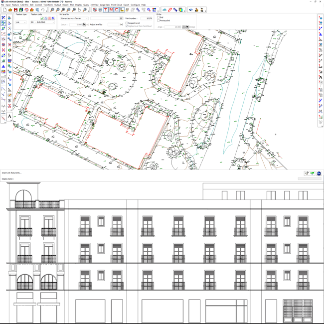
Building elevations
-
Interactive on-screen editing of points, features, text etc
-
Quality Assured CAD-Pro editing tools including intersections, squaring, offsets, generation of extra points along strings etc
-
User-definable features and symbols
-
Cut and paste surveys
-
Add one survey to another (useful if different survey teams are processing different parts of a survey)
-
Scale factors and model transformation (offset, rotation, re-scaling)
-
Printing of plans and sections
-
Input of data from other systems, such as DXF for AutoCAD™ and Ordnance Survey MasterMap (GML)
-
Interrogate and import from MX (MOSS) Model files
-
Export ESRI ASCII Grid format (in addition to import of this format in Solo)
-
Export to selected GPS Machine Control Systems
-
Query maximum, minimum and total lengths of selected linear features
Powerful Terrain Modelling:
-
Automatic formation of DTMs (Digital Terrain Models)
-
Dynamic contouring - automatic generation of contours at any interval, updated in parallel with changes to DTM
-
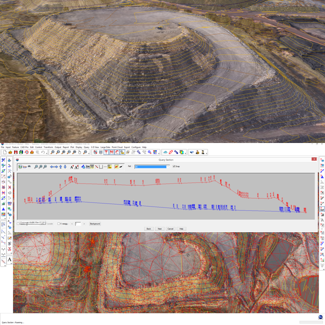
Interrogation of DTMs, including level interpolation, section profiles and distances between points/along features
-
Superimposition of up to 36 surveys on screen - to query points, distances and to check extents etc
-
Terrain, non-terrain and 2D feature manipulation
-
Bitmap image backdrop (i.e. orthophoto or raster map)
-
Application of surfaces to distinguish between surface types, e.g. tarmac, grass, water etc (all user-definable)
-
Calculation of slope and plan areas and perimeter lengths, broken down by surface types if required
-
Models of up to 4 million points
-
Powerful data thinning for importing larger datasets
Volumes, sections, 3D views and machine control:
-
 3D views and realtime fly-bys (virtual tours). Textures may be applied to the DTM in order to represent different materials or zones and images applied to point and link features to represent such things as trees, hedges, walls, fences and buildings
 -
Raster maps and aerial orthophotos may also be draped onto the DTM with the minimum of user intervention and the combined model flown or walked through in real time with joystick, gamepad or keyboard control of 3D virtual tours
-
Display up to 36 DTMs in the same 3D view simultaneously, with full control over transparency
-
Animated water 'flood' level facility within the 3D view and virtual tourLand Surveys and Designs using LSS
-
Calculation of volumes between two surveys, broken down by surface feature if required, using cross sections or highly accurate complex triangular vertical prisms
-
Volumes can take into account formation level information such as concrete slab thickness or road construction depths
-
Calculation of areas and volumes to a datum, as defined by surface features if required
-
Plotting of sections through up to 50 DTMs simultaneously to any Windows-compatible printer or plotter or DXF file
-
Reporting and export of section data
-
Determination of Ponding Extents for the analysis of ponded water
Our most comprehensive design, reporting and modelling system:
-
Advanced terrain design employing wizards and user defined shapes or 'templates' eg for slopes, embankments, opencast mines, quarries etc
-
Extremely comprehensive volume calculation facilities, including breakdown by surface type, zones, cut depths etc
-
Volumes above and below a third model, datum or tilted plane
-
Output of cut/fill intersection lines and 'depth' lines
-
Generation of isopachytes (level difference contours)
-
Calculation of Overburden Ratio
-
Addition/subtraction of levels in one DTM to/from another including multiplication (for pre- and post-settlement calculations, merging data where only higher or lower than existing, bulking factors etc.)
Specialist capabilities:
-
 Zones of Visual Influence and Intrusion (ZVIs and ZTVs)
 -
Line of Sight (Viewshed Analysis)
-
Visibility profile for determining maximum permissible development heights (constraints)
-
Floor Level Assessment - testing for surfaces which are beyond tolerance in level, thickness or smoothness (The Concrete Society NSCS Standards 2004)
-
Planing Depth calculations of use to those reprofiling roads and runways
-
Rail survey adjustment (to adjust rail overlaps), rail gauge reporting and platform clearance calculations for those undertaking railway surveys using EDM and GPS survey equipment
Our Point Cloud capabilities:
-
Creation of Point Clouds from E57, LAS, LAZ, FARO FLS, Leica Geosystems PTS, XYZ
-
With or without Intensity (a single numeric value which can be used to colourise the data)
-
With or without RGB colouration
-
Automatic point outlier recognition and removal
-
Over display LSS survey in the point cloud
-
Eraser tool to remove unwanted points
-
Extract a terrain from the Point cloud to create an LSS survey
-
Use the Point Cloud application as a 3D digitiser to extract 3D lines and points
-
Create elevations and topographical surveys
-
World's first SearchphereTM technology to find points which are Highest, Lowest, Nearest to the eye, Furthest from the eye, Mean of points within the Searchphere, or Closest to the user click
-
Searchphere "Find Edge" and Searchphere "Find Plane" in realtime
-
Export of E57 for use by other software
-
LSS 3D VisionTM application is a free Point Cloud and LSS survey viewer which doesn't require a dongle.
Point Clouds in LSS 3D Vision:
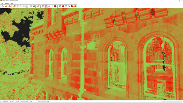
Courtesy RPS Planning and Development and Natural History Museum
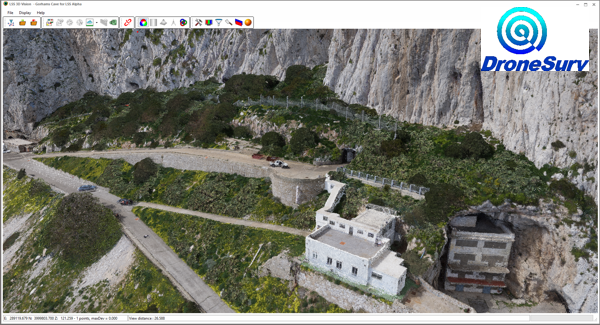
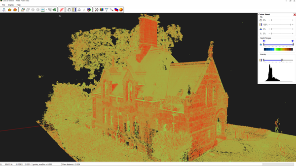
Courtesy Drone Surv
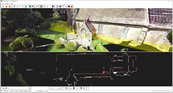
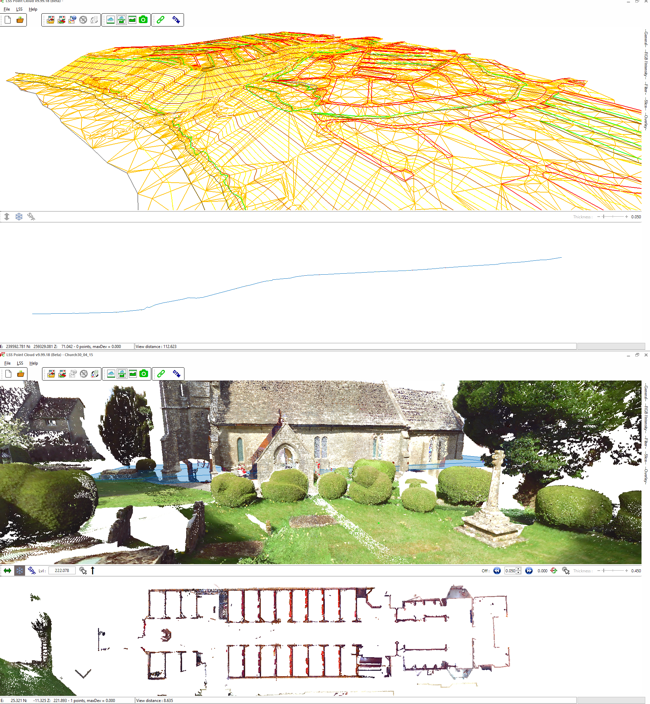
Church external and horizontal slice (MTSL in-house test scan)
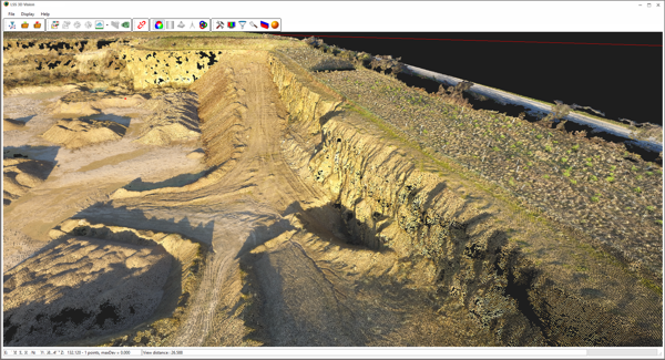
Courtesy OcuAir