
New ways to present hydrographic data have been introduced to satisfy those wishing to work to Admiralty or Engineering survey standards. Equally suited to intertidal, nearshore or deep sea operations, LSS allows the user to present the terrain surface and annotate to the internationally recognised hydrographic standards. As point elevation labels are displayed 'on the fly' it is possible to switch between labelling nomenclature at any stage and plot or export knowing that the settings have been implemented and will be transferred accurately to AutoCAD™. In those surveys where some points are above and others below the chart datum, LSS automatically displays hydrographic and land elevations and contours in the correct manner without the need for any user intervention.
For the benefit of those involved in design and dredging, LSS contains many powerful 3D terrain design functions, specifically for trench and sea wall design, pipeline and reclamation projects.
In use by dredging and hydrographic survey companies
Displays, plots and exports models with the correct Admiralty or Engineering level and contour display details
Used for volume calculations and trench and sea wall designs
Compare models and display level changes
Automatically handles a mixture of land and hydrographic survey data
Change label display 'on the fly' and at any stage without affecting the base survey data
Fly-bys and colour banded 3D views
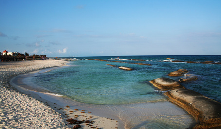
LSS has been used for beach and coastal surveys since the very early days of the software. At that time 'two-man' teams would use EDM survey equipment to measure a beach. More recently however, with the threat of coastal erosion due to rising sea levels and the increased risk from damaging storms many organisations are now required to monitor stretches of coastline and beaches much more frequently.
One solution to providing quick and accurate beach surveys has been the use of a GPS antenna mounted on a 4 wheel drive All Terrain Vehicle (ATV). This setup allows hundreds if not thousands of surveyed points to be collected in a day.
The Problem
In spite of the obvious advantages of this method, there is one major disadvantage. When the ATV is driving along a sloping beach the pole of the antenna is not vertical which means that the surveyed points are not where they should be. The diagram below illustrates the problem.
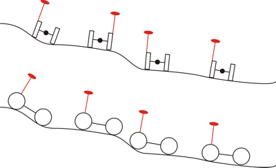
While, for gently sloping beaches the error will be minimal, when traversing beach berms and storm ridges the errors can be quite large. The table below gives you some idea of the likely errors.
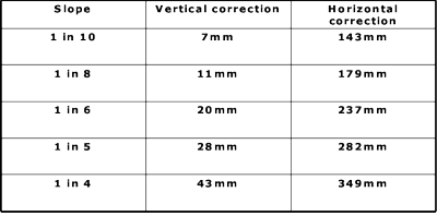
The above table assumes a 1.4m pole height, 1.2m wheelbase length and 1.0m wheelbase width.
The Solution
What we have done in LSS is provided a solution to this problem and it is called 'GPS Pole Verticality Correction'. This command will make the necessary adjustments to every point which was surveyed from the ATV and generate a corrected terrain model. This command is available in LSS Solo, although the minimum that would be required in order to calculate volumes (often a requirement of beach surveys) would be LSS Vista.
While this survey method may have been superceded by UAV, LiDAR and Laser Scanning methods in recent years, this article serves to illustrate our commitment to providing innovative solutions to a wide range of problems.